ABOUT DHOLERA SIR PROJECT
DHOLERA is situated in Ahmedabad district in the Gulf of Khambhat.
Dholera is in proximity with the coastal line. It is covered by water faces on three sides, namely, on the east face by Gulf of Khambhat, on the north side by Bavaliari creek and on southern side by Sonaria creek.
Proximity to Ahmedabad has provided Dholera a strong locational advantage with a vibrant manufacturing base and investment scenario.
The project is spread over an area of 35,000 hectares. The processing area which is proposed is 14,000 hectares and rest is non- processing zone.
project vision
To develop Dholera Special Investment Region (SIR) as global manufacturing and trading hub i.e. “The engine for economic resurgence of the country” which is supported by world class infrastructure.
“The Development Plan, taking into account the DMIC objectivs and goals, should focus towards creating and enabling environmentto protect local industries, enhance investment climate, improve quality of life, upgrade human skils, create world class infrastucture and attract global investment”.
Project goals are to double the employement potential, triple industrial output and quadruple exports from the region in next five years.
Connectivity
Distance
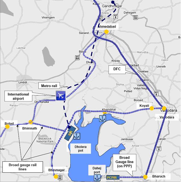
National Highway 8 connects the Dholera Special Investment Region with Ahmedabad, Bhavnagar and Mumbai. Dholera itself has good connectivity with National Highway (NH) 8 (Anand) and 8A (Bagodra), augmenting Bagodra -Bhavnagar, Bagodra- Surendranagar- Radhanpur links.
As a part of Golden Quadrilateral, the 500 km Mumbai- Ahmedabad- Vadodara Express way connects the region.
In order to make the region more assessable, an airport and a port are proposed in this region.
The port site is proposed to be connected by road with Ahmedabad – Bhavnagar highway at a distance of about 11 kilometres. Almost 2,057 hectares of Government land was allocated for the development of port site.
Rail connection is being planned for Dholera, while the nearest meter gauge connection is Bhavnagar (34 km) and the nearest broad gauge station is Tarapur (103 km).
| Important Cities | Distance (in km) |
|---|---|
| Mumbai | 516 |
| Delhi | 815 |
| Surat | 278 |
| Rajkot | 225 |
| Gandhinagar | 128 |
| Ahmedabad | 108 |
Map –Road Connectivity to Dholera:

Map –Rail Connectivity to Dholera:
More about dholera sir PROJECT
Dholera SIR : Ideally located, widely connected…
- Total Area: 920 Sq. km
- Developable Area: 567.39 Sq. Km
- High Access Corridor: City Center, Industrial, Logistic, Knowledge & IT, Recreation & Sports, Entertainment
- World-class infrastructure & connectivity: within & outside
- Central spine express way & Metro Rail to link the SIR with mega cities
- Airport & Sea Port in the vicinity
- Proximity to mega cities: Ahmedabad, Bhavnagar, Vadodara
- Benefit of sea coast, nature park, golf course
- Premium civic amenities
- Capable to cater to both International & Domestic Market
- Close to Guajrat International Finance TechCity (GIFT)
- Close to Petro-chemicals and Petroleum Inv. Region (PCPIR)
- Logistic support of the Dedicated Freight Corridor (DMIC)
- Benefits of the high impact Delhi Mumbai Industrial Corridor (DMIC)
- Public investment in core infrastructure
- A self governed economic region enjoying full support of the government and full potential for private sector participation
- Logistic support of the Delhi-Mumbai Dedicated Freight Corridor linked with efficient rail and road network.
- To be linked with Ahmedabad city with metro rail system
- Proximity to sea port, Closeness to international airport
- Premium civic amenities
- Close to Gujarat International Finance City (GIFT)
- Close to Petro-chemicals and Petroleum Inv. Region (PCPIR)
- Autonomy in operations
- Flexibility in decisions
- Single window clearance
- Dispute Resolution mechanism
Dholera SIR : A Self governed global centre of economic activities…
- Empowered mechanism for administration
- Autonomy in operaions
- Flexibility in decisions
- Freedom in planning
- Commitment to adopt best practices
- Full potential for private sector participation
- Fully developed environment & framework for PPP
- PSP modes : BOT, BOOT etc already operational
- The work on the central spine road already started
- Government allocates 1700 Hect. land for adjoining Airport
- Anchor Tenants already in place
- Water logging, seismological & environment studies underway
- The legal framework enacted: The SIR Act 2009
- Project development corporation (GICC) formed
- Development Plan sanctioned on 10 /09/2012
- Town Planning Scheme (TPS) no. 1 and 2 sanctioned on 3/10/2012
- Town Planning Scheme no. 3, 4, 5 and 6 have been submitted to Apex Authority (GIDB) on 13/12/2012 for sanction
- Tenders for selection of consultants for preliminary design of roads including utilities for TPS no. 2 have been floated
- To build the industrial parks, townships, knowledge cities
- In building its infrastructure: road, rail, hospital, water, sanitation, tourism, and hospitality
- Set up the metro rail system & international airport
- Potential for development as a multi-modal transportation hub due to lesser distance to all the northern Indian States.
- Build world class transport service foreign markets